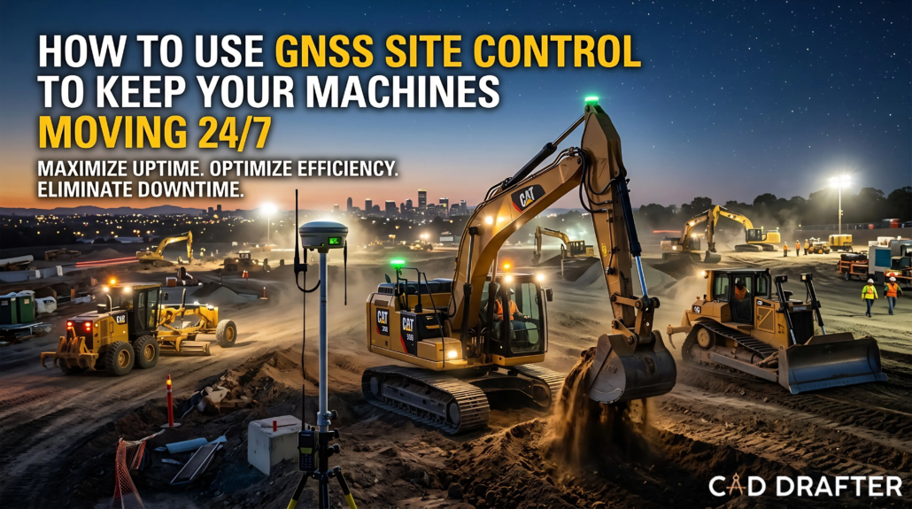
How To Use GNSS Site Control To Keep Your Machines Moving 24/7
If your dozers are sitting idle because a survey stake got knocked over, you’re bleeding money. In modern earthmoving, the difference between winning a bid and losing your project often comes down to one single metric, which is machine uptime. That’s when GNSS site control enters the chat!
This isn’t your granddad’s GPS. Today’s Global Navigation Satellite System (GNSS) machine control is the ultimate 24/7 heartbeat of the modern construction site. It converts heavy iron into precision instruments, syncing blades and buckets to a digital twin with millimeter accuracy.
GNSS is your best bet to get a jobsite where productivity keeps shining even when the sun goes down. That ultimately means contractors won’t be waiting for surveyors or second-guessing the grade anymore. Besides, it keeps machines running even in severe weather conditions like heavy fog.
If you are running a construction drafting and modeling business, your clients rely on highly accurate 3D models. But those models are virtually useless if the machinery on the ground can’t read, interpret, and execute them flawlessly around the clock.
This blog will help you comprehend how to use GNSS site control to eliminate bottlenecks, automate grading, and keep those machines moving relentlessly, day or night.
Why GNSS is Your Secret Weapon in 2026
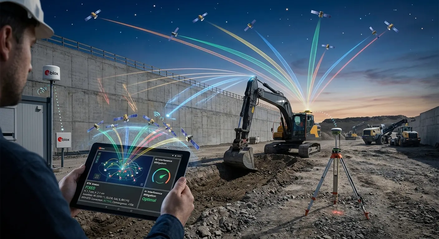
There’s no doubt that GNSS is a new way of getting precise positions for industrial machinery. However, before we analyze why, it is necessary to clear up one misconception. Most people think GNSS and GPS are the exact same thing, but they aren’t!
When it comes to the GPS, the whole system is no more than a constellation of satellites. On the contrary, GNSS is one whole heavyweight squad.
GNSS Concepts Are 2026
2026 is changing significant factors in GNSS equipment. As of April 2026, new GNSS modules are entering their sample and testing phases. Besides, AI-powered interfaces are also getting launched to counter interference. All of this will provide accurate positioning for autonomous and IoT-based systems. Here are some common GNSS-related advancements in 2026:
- Access to the US GPS
- Russia’s GLONASS
- Europe’s Galileo
- China’s Beidou Network (50-satellite network)
When a dozer is carving out a trench near a massive concrete retaining wall, standard single-constellation signals bounce. They get weak. They drop out completely. Multi-constellation GNSS systems drastically reduce these “multipath errors” and signal blockages. They guarantee that your machinery always has a direct line of sight to the sky’s positioning data, no matter where they are on the site.
But just pulling down satellite data isn’t enough. To achieve the centimeter-level accuracy required for finish grading, GNSS is paired with Real-Time Kinematic (RTK) technology.
● The Magic of RTK:
A base station sits on a known point on your site. It receives the exact same satellite signals as your roaming excavators and dozers. Because the base station knows precisely where it is, it calculates the signal error and instantly broadcasts a correction via radio or cellular modem directly to the machines.
● The PPP-RTK Upgrade:
Newer testing networks, like u-blox’s PointPerfect Flex, use PPP-RTK (Precise Point Positioning – Real-Time Kinematic). It helps the GNSS specialists deliver accurate and scalable corrections. But that’s not even the best part. These corrections have lightning-fast convergence times that strip away the hassle of managing local base stations entirely.
Eliminating Costly Earthmoving Downtime
How exactly does this keep a machine moving 24/7? It fundamentally rewrites the traditional earthmoving workflow.
Traditional ways are no longer a match for GNSS workflows. In the old times, a surveyor hammered wooden stakes in the ground while the grader operator eyeballed the stake. The same operator made a pass, stopped, got out, checked the grade, got back in, adjusted, and made another pass once again. Sounds hectic, right? But that’s not the only problem! If a skate got run over, everything stopped until the survey crew came back. Also, in the unpredictable instance of rain, work stopped immediately.
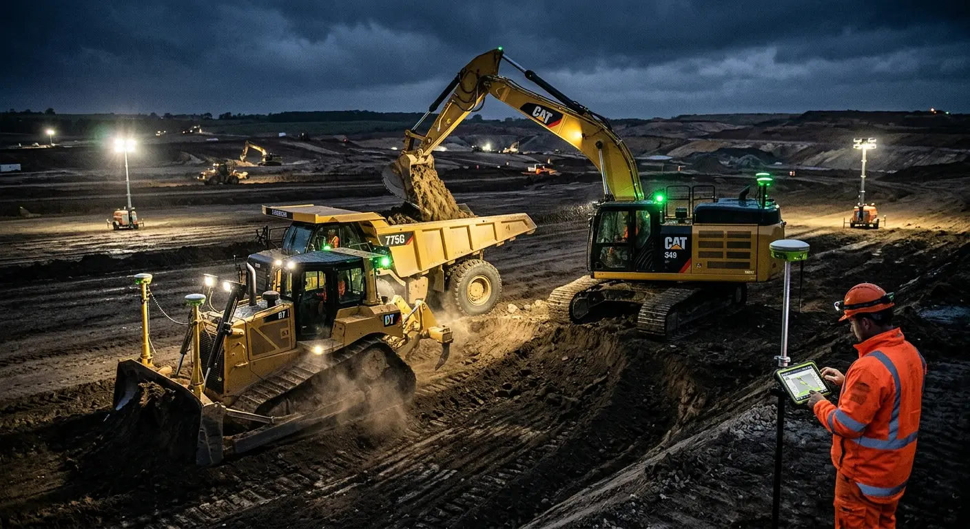
With 3D GNSS machine control, the site plan lives inside the cab’s display. Here is exactly how it maximizes uptime:
1. Stakeless Grading:
You completely eliminate manual staking. Your operators have a live 3D map right in front of them, showing their exact position relative to the final design grade. They dig or pave right the first time.
2. Automated Blade Control:
Systems like Topcon’s 3D-MC software literally take the wheel. The GNSS receiver talks to the machine’s hydraulics. As the tractor moves over uneven terrain, the blade automatically raises and lowers to match the 3D design file perfectly. The operator just steers.
3. Night-Shift Domination:
Unlike the stake-oriented system, 3D GNSS does not need to read construction drawings or get help from visual markers. Crews can operate at 2:00 AM and get the same result as the team working at 2:00 PM. Any unpredictable or uncontrollable factor (dust, darkness, fog, or rain) is no longer a problem.
4. Instant Progress Tracking:
The machines act as roving surveyors. That means everything is accounted for. Machines keep a record for exactly how much dirt has been moved. At the same time, real-time as-built data is sent to the cloud. Project managers use the information to adjust logistics on the fly without stopping any operation.
The broken-down operational differences below will help you understand everything in a jiff.
Traditional vs. 24/7 GNSS Machine Control
| Operational Factor | Traditional Construction Methods | Modern GNSS Machine Control | Uptime Impact |
| Site Preparation | Requires days of manual staking and layout by a specialized survey crew. | Upload a 3D model directly to the machine via cloud. Grading starts instantly. | Massive. Eliminates days of preliminary downtime. |
| Grade Checking | Constant stopping to manually check grade using lasers or string lines. | Real-time, continuous grade feedback displayed live on the in-cab monitor. | High. Machines never stop to verify elevation. |
| Weather/Lighting | Heavy dependence on daylight and clear visibility to read stakes. | The system relies on satellite data. Operations continue seamlessly in the dark or fog. | Extreme. Opens up the possibility of genuine 24-hour shifts. |
| Error & Rework | High probability of human error, over-excavation, and costly rework. | Centimeter-level automated accuracy prevents undercutting and overfilling. | High. Moving dirt once saves fuel, time, and machine wear. |
| Communication | Disconnected. Engineers rely on end-of-day reports or manual site visits. | Connected. Real-time BIM-GIS integration. Design changes sync instantly. | Moderate. Prevents delays caused by outdated blueprints. |
Overcoming The Blackout: Next-Gen Uptime Technology
Contractors often wondered what would happen when the excavator drives under an extremely dense tree canopy. Simultaneously, construction companies asked GNSS specialists how a machine would work next to a towering high-rise that blocks the sky.
There was only one answer: things won’t work the same anymore. The system would drop out immediately, and the machine would sit idle until the operator finds a fix. However, recent breakthroughs changed everything. The industry has aggressive, bulletproof workarounds to ensure absolute continuous operation.
Bridging the RTK Gap with SmartLink
When communication drops between the base station and the machine’s receiver (maybe a truck parked in front of the radio antenna), you lose RTK corrections. Premium systems today utilize “fill-in” technologies. For example, Leica’s SmartLink can bridge RTK communication gaps for up to 10 minutes. It uses alternative satellite-based corrections to maintain high accuracy during the blackout. Ten minutes might not sound like much, but in the earthmoving world, it’s the difference between completing a pass and halting production.
The Power of Precision Timing Oscillators
Deep inside industrial GNSS hardware are robust clocks. When a signal is lost, the system goes into “holdover” mode, relying on its internal clock to guess its position until the signal returns. Modern MEMS-based timing solutions offer frequency stability down to ±0.05 ppm. It means these rugged, vibration-resistant oscillators maintain tracking accuracy even during severe temperature shifts or harsh shock environments (like an excavator hammering through solid rock). Fast warm-up and robust holdover reduce reacquisition time to mere seconds.
Sensor Fusion and IMU Integration
When satellites fail entirely (say, driving deep inside a tunnel), GNSS relies on its friends. Today’s systems pair satellite receivers with an Inertial Measurement Unit (IMU).
What Is IMU And How Does It Help?
IMU is more like an inner ear for the system. It tracks the machine’s pitch, acceleration, and roll through advanced digital methodologies. In industrial applications, when the GNSS signal is lost, IMU jumps in to help and calculates the machine’s exact movement via its last known location. The fact that all of this happens instantly ensures your operators don’t even notice a blip on the screen.
5G and IoT Synergy
As of 2026, GNSS is continuously getting paired with digital twin, IoT devices, and 5G network applications. The combination of these two technical factors creates a synergetic and highly resilient Position, Navigation, and Timing (PNT) system.
In urban canyons where satellites are completely obstructed, the machine seamlessly switches to drawing highly accurate positioning data from the ultra-low latency 5G grid, preventing the screen from ever going dark.
Get Expert’s Insights About GNSS In A Click!
Deploying the Right Hardware for Relentless Earthmoving
You can’t run a 24/7 operation on cheap consumer tech. Construction-grade GNSS hardware must be virtually indestructible. When advising your clients on how to implement your drafting models in the field, you need to understand the hardware ecosystem backing them up.
The brain of the operation is the GNSS receiver. These units must feature multi-frequency tracking capable of monitoring up to 60 satellites simultaneously. But computing power is nothing without physical durability.
Every receiver needs reliable and heavy-duty casing that can withstand bone-rattling vibration of dozer and excavators. This physical durability is necessary to avoid corruption of the internal data flow.
Here are some essential elements of a top-tier setup:
● Built-in Modems vs. External Radios:
Flexible communication is a common attribute of modern setups. For larger sites with cellular coverage, a built-in 4G/5G modem works like a charm using Virtual Reference Station (VRS) networks. But when it comes to remote locations, you will need a setup that can switch to external UHF radios. That’s how a system grabs signals from your local base station. The best hardware handles this switch automatically, without forcing the operator to navigate clunky menus.
● Dual GNSS Heading Systems:
A single antenna tells you where the machine is. Two antennas tell you exactly where the machine is pointing. Dual GNSS setups are crucial for excavators. By placing two antennas on the back of the machine, the system calculates the exact heading and pitch of the entire body. This allows the onboard computer to precisely calculate the position of the bucket teeth in three-dimensional space, regardless of how the tracks are physically oriented.
● Edge Configuration Technology:
Groundbreaking updates like the 3D-MC Edge configuration focus the processing power directly on the machine’s cutting edge. This dramatically improves the responsiveness of the hydraulics for fast-moving equipment like wheeled tractor-scrapers or motor graders. It ensures that even at high speeds, the blade adjusts instantly to the terrain, guaranteeing a perfect finish grade in record time.
The goal here is seamless, invisible technology. The operator shouldn’t be fighting with a controller or rebooting a receiver. They should be looking out the windshield, moving dirt. When the hardware is rugged, the firmware is updated over the air, and the data flows effortlessly from your drafting office straight to the ground, true 24/7 productivity isn’t just possible, it becomes the new baseline.
Read more: https://caddrafter.us/reshaping-construction-with-modular-design/
Everything About Translating 3D Models into Biting Edges
Let’s face the hard truth. A stunning, mathematically perfect, clash-free 3D model is basically just a fancy video game if it doesn’t communicate flawlessly with the heavy iron on the ground.
This is where construction drafting and modeling firms become indispensable. You aren’t just selling blueprints anymore. You are producing executable Digital Terrain Models (DTMs). But how exactly does that massive data file get from a dual-monitor CAD setup in an air-conditioned office to a vibrating cab in the middle of a muddy, midnight shift?
File synchronization and cloud-based telematics are the answer. Back in the days, someone drove out to the site with a USB and plugged it into the machine’s display for updating the files. That means even if the engineer came across one design error at 3:00 PM, machines might keep running on the wrong data until the next morning. Now that’s downtime.
Today, platforms like Trimble WorksManager or Topcon Sitelink3D act as the invisible, high-speed bridge between your drafting team and the operator’s joystick.
● Instant Design Sync
Just like cloud-based CAD collaboration, when your modelers tweak a retention pond’s slope or adjust a road alignment, they push the updated DTM to the cloud. Within seconds, the in-cab display alerts the operator of a file change. The machine updates over the air. No USBs. No driving. No working off outdated plans.
● Universal Formats
The best GNSS setups process standard industry formats like LandXML, DXF, or proprietary optimized files without lag. Your 3D linework directly translates into hydraulic commands.
● Remote Troubleshooting
Say a dozer operator is confused about a specific grade transition. Instead of halting production to call a foreman, your office team can remotely log into the machine’s screen. They see exactly what the operator sees, in real-time. They can guide the blade, fix the view, and get the machine moving again in under three minutes.
Defending Your Margins: The Brutal ROI of Continuous Uptime
Why invest the massive capital required to outfit a fleet with GNSS site control? Because earthmoving is a game of pennies won by moving tons. Moving dirt twice is the cardinal sin of the construction industry. It destroys profit margins faster than bad weather.
When you leverage GNSS to keep machines moving 24/7. The return on investment isn’t just about speed. It is about surgical efficiency.
| Efficiency Metric | Without GNSS Site Control | With Full 3D GNSS Automation | Profit Impact |
| Material Yield | High risk of over-excavation. Requires expensive imported fill to correct errors. | Cuts strictly to design grade. Zero over-digging. | Saves thousands in wasted material costs per project. |
| Fuel Consumption | Machines idle while waiting for surveyors or grade checkers. Multiple passes needed. | Zero idle time for grade checks. Grade is hit on the first or second pass. | Slashes fuel burn rates by up to 30%, crucial for tight bids. |
| Machine Wear | Unnecessary passes grind down undercarriages, cutting edges, and engine components. | Optimized routing and fewer passes drastically extend the lifecycle of wear parts. | Lowers total cost of ownership (TCO) and maintenance overhead. |
| Labor Utilization | Requires a dedicated grade checker dodging heavy equipment in the dirt. | The operator is the grade checker. Reallocates ground labor to safer, higher-value tasks. | Maximizes payroll efficiency and heavily reduces site safety risks. |
Think about the bidding process in 2026. Contractors using traditional methods have to pad their bids to account for weather delays, daylight limitations, and inevitable rework. A contractor equipped with a fully connected, GNSS-automated fleet knows exactly how long a cut will take, down to the hour. They can bid tighter, win more jobs, and still maintain a given timeline.
Preventative Maintenance: Keeping the Iron Alive Under Pressure
There is a catch to running machinery 24 hours a day. If the GNSS says “go,” but a blown hydraulic line says “no,” you’re still dead in the water.
When you eliminate survey delays and weather bottlenecks, the ultimate limiting factor becomes the mechanical health of the equipment itself. Running 24/7 accelerates wear and tear exponentially. Therefore, true site control isn’t just about positioning; it’s about integrated telematics.
Modern GNSS receivers don’t just talk to the blade; they pull data from the machine’s CAN bus (Controller Area Network). This creates a holistic, live feed of the equipment’s health.
- Predictive vs. Reactive: Instead of waiting for an engine to overheat during a night shift, the system monitors coolant temperatures and pressure differentials in real-time. If a metric spikes, the project manager gets an alert on their phone. You pull the machine down for a 20-minute fix before it becomes a catastrophic, multi-day engine failure.
- Geofenced Maintenance: As machines rove across massive infrastructure projects, finding a broken-down scraper can waste hours. Because the machine is tracked via GNSS, the lube truck or mechanic gets precise GPS coordinates routed directly to their tablet, minimizing diagnostic and travel time.
Elevating the Operator: The Human Element in a Digital Jobsite
Let’s address the elephant in the room. Does automated machine control replace the heavy equipment operator?
Absolutely not. It elevates them. There is a massive misconception that 3D GNSS turns bulldozers into giant, autonomous robots. While fully autonomous earthmovers are currently being tested on isolated mine sites, the dynamic, chaotic environment of a commercial construction site still fundamentally requires human intuition.
GNSS technology shifts the operator’s cognitive load. Instead of staring out the window, desperately trying to read a grade stake covered in dust while simultaneously feathering the blade controls, they become in-cab site managers.
The system handles the micro-adjustments. The blade raises and lowers with sub-centimeter precision automatically. The operator, meanwhile, focuses on the macro-strategy. They manage the most efficient way to stockpile topsoil. They monitor surrounding safety hazards. They optimize their push distances.
When a rookie operator sits in a GNSS-equipped cab, their learning curve is slashed in half. They can achieve finish-grade results that would traditionally take five years of seat-time to master. For construction companies struggling with the ongoing skilled labor shortage, this technology is the ultimate equalizer. It allows you to produce top-tier work with a wider pool of talent, ensuring your fleet is never parked simply because you couldn’t find a veteran grader.
Handling Complex Topography with Unshakeable Precision
Finally, we have to look at the geometry of modern architecture. We aren’t just building flat parking lots anymore.
Modern landscape architecture and infrastructure design involve complex curves, super-elevations, undulating golf courses, and highly engineered drainage swales. Staking these designs manually is an absolute nightmare. It requires a forest of wooden stakes and a massive margin for error.
By integrating your 3D models with the machine’s GNSS control, complex topography is handled exactly like a flat plane. The machine simply follows the digital contour. When an excavator operator needs to dig a V-ditch with a specific slope, the bucket teeth are guided by the DTM, perfectly carving out the complex geometry without a single physical reference point on the ground. This capability alone justifies the investment for companies taking on high-end, highly engineered civil projects.
Conclusion
At the end of the day, earthmoving is a ruthless race against time, weather, and margins. GNSS site control isn’t just a fancy gadget; it’s the lifeline that keeps your heavy equipment cutting, pushing, and grading 24/7. By bridging the gap between highly accurate 3D drafting models and rugged field hardware, you eliminate the sheer guesswork that causes downtime. Your machines don’t stop for missing stakes, bad lighting, or lost plans. They just work. For construction companies ready to dominate their local markets, integrating seamless, cloud-connected GNSS technology is the ultimate trump card.
Frequently Asked Questions
What is the main difference between GPS and GNSS?
GPS is a single US-owned satellite constellation. GNSS refers to the global network, including GPS, GLONASS, Galileo, and BeiDou. Using GNSS provides multi-constellation redundancy, drastically reducing signal dropouts and keeping your machinery moving without interruption.
Can GNSS machine control really work at night?
Absolutely. Unlike human operators relying on visual survey stakes and daylight, GNSS receivers read digital terrain models via satellite signals. This allows for pinpoint grading accuracy in total darkness, heavy fog, or severe dust storms.
How do 3D drafting models integrate with field equipment?
Specialized drafting teams create digital terrain models (DTMs). These are pushed via cloud software directly to the machine’s in-cab display. The onboard computer reads the file and automatically adjusts the hydraulic blades to match the design.
What happens if the GNSS signal is lost completely?
Modern systems use Inertial Measurement Units (IMUs) and premium bridging technology like SmartLink. If satellites are blocked, internal sensors calculate the machine’s exact movement based on its last known position, preventing any sudden work stoppages.
Does automated machine control replace the heavy equipment operator?
Not at all. It elevates them. The technology handles the micro-adjustments of the blade, but the operator is still vital for steering, managing site safety, avoiding obstacles, and optimizing the overall strategy of the earthmoving process.
How much fuel can 3D GNSS machine control save?
By eliminating over-excavation and rework, machines move the exact amount of dirt required on the first pass. Contractors routinely report fuel savings of up to thirty percent, significantly boosting profit margins and meeting strict environmental standards.
What is RTK and why is it necessary for grading?
Real-Time Kinematic (RTK) technology uses a local base station or network to correct standard satellite signal errors. It broadcasts these corrections directly to the rover, achieving the sub-centimeter accuracy required for precise finish grading applications.
Do I need a local base station for GNSS control?
Not always. While local base stations offer rock-solid reliability, modern PPP-RTK networks deliver cellular-based corrections directly to your machines. As long as you have robust 5G or LTE coverage, you can often bypass local base hardware.